Submitted Jul 3, 2026 at 9:04 PM• 2 days ago
Updated Jul 3, 2026 at 9:05 PM
• 2 days ago
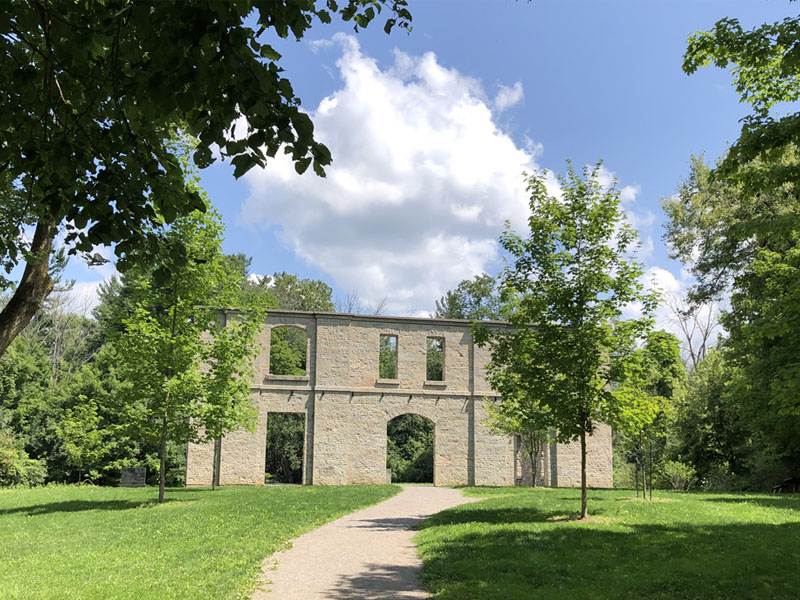
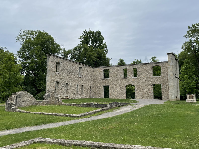
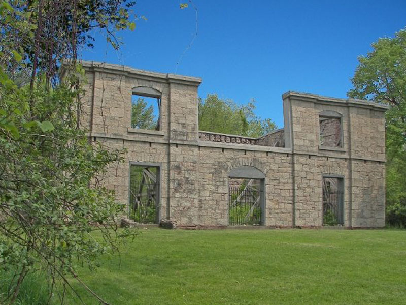
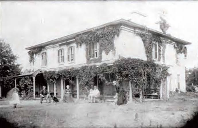
Built around 1830 in Ancaster (Hamilton), Ontario, The Hermitage was a grand stone mansion that tragically burned in 1934.
The atmospheric ruins of its thick walls and foundations now stand preserved in a scenic conservation area within the Dundas Valley, surrounded by hiking trails and old-growth forest.
Part of the Hermitage and Gatehouse Museum, these haunting stone remnants are a popular spot for explorers, history lovers, and ghost hunters chasing local legends, a beautiful and eerie slice of early Ontario heritage amid the trees.
Collection:
--
Submitted Jun 9, 2026 at 6:28 AM• a month ago
Updated Jun 9, 2026 at 6:30 AM
• a month ago
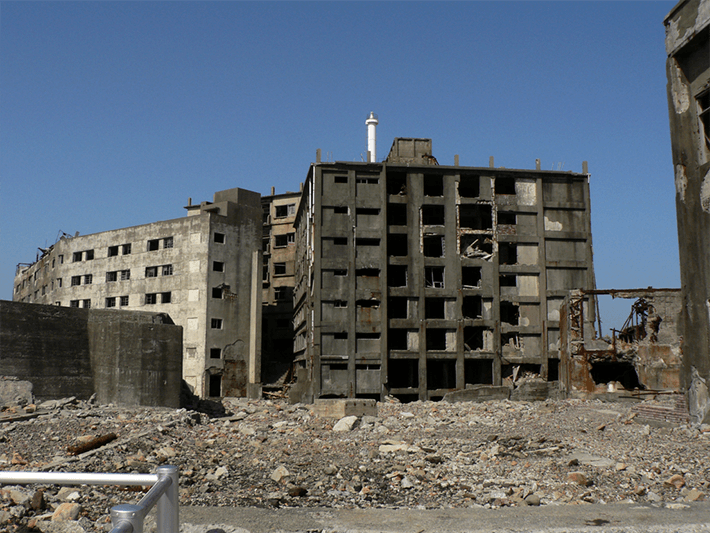
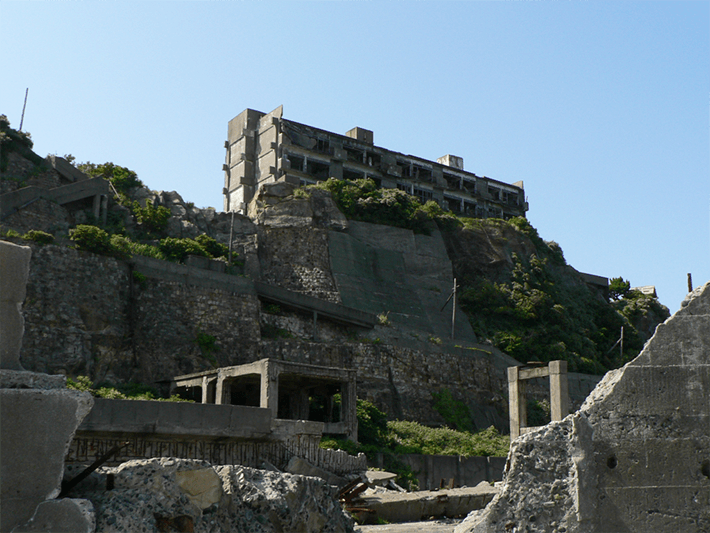
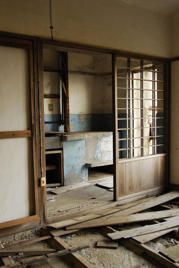
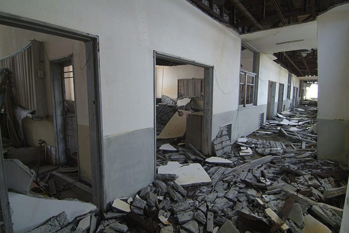
Hashima Island (端島), better known as Gunkanjima or Battleship Island, lies 15 km off Nagasaki, Japan.
From 1887 to 1974 this tiny 6.3-hectare rock was a Mitsubishi undersea coal mining community that once packed over 5,200 residents into dense concrete high-rises, one of the most crowded places on Earth at its 1959 peak.
When the mine closed in 1974 the entire population left overnight, leaving behind a haunting city of crumbling apartments, schools, hospitals, shops and factories frozen behind a massive seawall.
Today its decaying concrete skeleton rises from the sea like a ghostly battleship , a legendary urbex icon, UNESCO World Heritage site, and the real life inspiration for the villain’s lair in Skyfall.
Collection:
--
Submitted Mar 16, 2026 at 7:52 PM• 4 months ago
Updated May 29, 2026 at 7:29 PM
• a month ago
Built in 1919 on Piquette Street in Detroit, steps from Henry Ford’s original workshop and towering over the I-75/I-94 interchange, this massive six-story Albert Kahn-designed GM factory produced car bodies for Cadillacs, Buicks and limousines until GM shut it down in 1984.
Briefly used by a paint company before full abandonment in 1993, it became one of Detroit’s most iconic and accessible urbex spots: endless graffiti-covered halls, raw decaying production floors, and killer rooftop views of the Motor City!
Collection:
--
Submitted Mar 13, 2026 at 5:25 PM• 4 months ago
Updated May 29, 2026 at 7:29 PM
• a month ago
Built in 1963 near Homestead in the Florida Everglades for NASA’s massive solid rocket motor tests during the Space Race, this legendary site was abandoned in 1969.
Explore eerie concrete silos (with a giant rocket still inside), overgrown test stands, and decaying buildings slowly reclaimed by nature, a true Cold War relic and must-see Florida urbex spot!
Collection:
--
Submitted Mar 10, 2026 at 9:33 PM• 4 months ago
Updated May 29, 2026 at 7:29 PM
• a month ago
Built in 1930 in BC's Flathead Valley, the historic Crevice Fire Lookout sits at 6,779 ft near the US border.
Though inactive, it offers views of grizzly-dense wilds and the Waterton-Glacier Peace Park.
Collection:
--
Submitted Feb 24, 2026 at 4:01 PM• 4 months ago
Updated May 29, 2026 at 7:29 PM
• a month ago
Mentmore Towers stands as a grand, decaying testament to Victorian opulence and lost fortunes in the Buckinghamshire countryside.
Its towering Neo-Renaissance silhouette, designed by Sir Joseph Paxton and built between 1852 and 1854 for Baron Mayer de Rothschild, once housed one of the era's finest collections of art and antiques; a showcase of unimaginable wealth for the powerful banking dynasty.
The mansion's ornate halls, vast ballrooms, and elaborate interiors echoed with elite society before the contents were controversially auctioned in 1977 amid death duties, scattering treasures that could have formed a national museum.
Subsequent owners, from the Maharishi Foundation to developer Simon Halabi, who dreamed of a luxury hotel... left ambitious plans unrealized. Water ingress, collapsing ceilings, and peeling grandeur now mark its slow decline, earning it a place on Historic England's Heritage at Risk Register in "poor" condition with immediate threats of further deterioration.
Famous as Wayne Manor in Batman Begins and a backdrop for other films, its exterior still commands awe amid overgrown grounds, while the interior whispers of faded Rothschild splendor and stalled revival.
A poignant symbol of architectural heritage left to rot, accessible only through careful (and often restricted) means in the urbex world.
--> Security and motion sensors are active on site. <--
Collection:
--
Submitted Jan 18, 2026 at 6:14 AM• 6 months ago
Updated May 29, 2026 at 7:29 PM
• a month ago
The former Bandimere Speedway (Thunder Mountain), a historic NHRA dragstrip in Morrison, Colorado, operated from 1958 until its closure in 2023.
Now inactive and in redevelopment transition, its grandstands, asphalt, and structures stand as remnants of 65 years of motorsport legacy at the base of the hogback.
Collection:
--
Submitted Jan 11, 2026 at 5:24 AM• 6 months ago
Updated May 29, 2026 at 7:29 PM
• a month ago
Overgrown rural hideaway: a weathered wooden shed with a tire art window stands beside a rusty, abandoned Winnebago RV, reclaimed by weeds and wildflowers in quiet decay.
Collection:
--
Submitted Jan 6, 2026 at 6:46 PM• 6 months ago
Updated May 29, 2026 at 7:29 PM
• a month ago
Carved into the an escarpment near Queenston in Niagara-on-the-Lake, Ontario,, the remnants of the historic Queenston Quarry Mine which was established in the 1830s as one of Canada’s earliest underground limestone operations.
Once a vital source of prized Queenston limestone used in landmarks like Brock’s Monument, the Welland Canals, and Ottawa’s Parliament Buildings, this early tunnel mine was largely obliterated when open-pit quarrying expanded, yet surviving passages now form a flooded, cavernous network of echoing chambers and submerged shafts, home to a protected bat colony.
Frequently inundated with knee-to-waist-deep water and mud, its hidden entrance guarded by conservation barriers amid dense trails, offers daring urban explorers a rare subterranean glimpse into Niagara’s quarrying heritage, reachable via off-trail hikes along the Bruce Trail escarpment; visit with extreme caution and respect for wildlife restrictions.
Collection:
--